Sunday, October 26, 2008
Ice Age Floods slideshow by Bruce Bjornstad
You'll enjoy this slideshow by Bruce Bjornstad. Awesome aerials of Ice Age Floods features. -Click to play
This Lake Missoula - Ice Age Floods video is also available for viewing at HUGEfloods.com.


Sunday, October 19, 2008
Deep Lake Potholes

I must have stood at this spot for 15 minutes Saturday - Amazing Ice Age Flood features surrounded me. In this shot the pothole, massive butte and hanging coulee all help one visualize the awesome power of the Ice Age Floods. I'm impressed with the large basalt overhang near the skyline. In Bruce Bjornstad's book "On the Trail of the Ice Age Floods" he describes this undercutting process that was key to the formation of vertical faces in recessional cataracts.
The Lillquist Ladders

At the last Ice Age Floods Institute meeting in Ellensburg, I was telling former Coulee City resident Karl Lillquist that I'd recently visited the east end of Deep Lake and that it was an interesting hike (stinging nettles, poison oak and a near-miss with a skunk). Karl asked me if I'd used the ladders. ...What ladders?
A few weeks later I decided to visit the area again and sure enough there are two well placed ladders that make the descent much easier. I should mention that beautiful Castle Lake is nestled into the upper alcove. Catch one of Bruce Bjornstad's presentations to view a great image of this lake.


The Interpretive Master Plan for the Ice Age Floods in Washington State Parks describes this group of kolk carved depressions - "Another spectacular feature is a tight cluster of the deep potholes beyond Sun Lake just west of Deep Lake. These potholes lie along the valley bottom and require only a 5-10 minute walk from the road."
Note from Tom: I've visited this group of potholes on three occasions - each time the road was gated back at the Camp Delany fork. You might want to allow more than 5-10 minutes for the walk. I'd also like to mention that a fall into one of these potholes could be fatal!
Check out the: Pothole Gallery

Black arrow upper left marks Deep Lake pothole cluster. Black arrow lower right notes Dry Falls Visitor center (WA State Parks).

Look for another Deep Lake post. I'll be back soon to walk around the lake.
Monday, October 13, 2008
Billy Clapp Lake
"Spring Coulee is a fine scabland canyon, with castle-like buttes, lateral subsidary canyons, and cataracts notching its walls"
J Harlen Bretz (1932)
We can no longer walk the floor of Spring Coulee as Bretz once did. Today the coulee carved by the Ice Age Floods is used to move and store Columbia Basin Irrigation Project water. Many of the Ice Age Floods features Bretz marveled at above the coulee floor are still visible along the shoreline of Billy Clapp Lake.
Bruce Bjornstad and I enjoyed a nice hike from Summer Falls to Pinto Dam Saturday. We found several great flood features during the hike. This shot shows Summer Falls and the USBOR hydro facility at the north end of Billy Clapp Lake.
During the construction of the Columbia Basin Irrigation Project, the Bureau constructed Pinto Dam at the south end of Spring Coulee to create Billy Clapp Lake. Irrigation water is pumped from the Columbia River at Grand Coulee Dam into the Grand Coulee (Banks Lake). To move water from Banks Lake to Billy Clapp Lake the Bureau used a series of canals, siphons and tunnels that have the capacity to carry 19,300 cubic feet of water per second. This water then flows south to irrigate 671,000 acres all the way to Pasco.
Lake named for one of the first to visualize Grand Coulee Dam -
William "Billy" Clapp (1877-1965), a lawyer in the small town of Ephrata. Clapp became convinced that whatever nature had done with ice in prehistoric times modern man could do with concrete. (From HistoryLink.org)
Grand Coulee Project - An opportunity created by The Ice Age Floods
Grand Coulee Dam (USBOR site)
Columbia Basin Irrigation Project (USBOR site)
Request Free Irrigation Project Brochure

Click USBOR map above to get a better look at the project. The Bacon siphons and tunnels are shown as #1 - The bifurcation point where the main canal splits into the East Low and West canal is shown as #2. Arrow points to Billy Clapp Lake.
In many locations the Bureau took advantage of Ice Age Floods channels to move water. Between Dry Falls Dam and Billy Clapp Lake they were forced to create their own channel through the basalt. First a canal was dug to feed water into the 1,000ft. Bacon Siphon that crossed Don Paul Draw. On the other side of the draw the siphon discharged into the two-mile long Bacon Tunnel. Project water then flowed through a canal system to Summer Falls. Years later a second siphon and tunnel were constructed.
You should be able to expand any of the images by clicking. That tunnel work doens't look like much fun.
NOTE: Black and white images showing canal, siphon and tunnel construction are from the Rufus Woods Collection housed at the Central Washington University Archives.

Bruce standing on a Giant Current Ripple. I'm on the next ripple downstream. Great place to get a feel for the power of the floods!

We found an impressive pothole about halfway through the hike. I need to start measuring these things.
Monday, October 6, 2008
Wallula Gap

UPDATE: I added a second Wallula Gap post to this blog after a November hike on the west side of the Columbia River. Click to open: Wallula Gap (West).
Hey!!! Check it out ... I'm not the last guy on the planet to start a blog! It seems like I'm always reading blogs and wanted to see how they're created and maintained so I just fired up this Ice Age Floods blog on Google's free Blogger program.
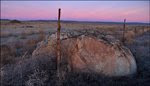
When I opened the "Edit Post" box I noticed an icon to add an image - I clicked it and selected the shot above of an ice-rafted "erratic" grounded high in the Horse Heaven Hills near Wallula Gap (15 miles from our house). So this is where the blog starts ... Wallula Gap.
A quick note about the images - I guess an easy way to date them would be to tell you that the ones with green grass were shot in the spring of 2006 - and the images with dead/brown grass were taken this week.

Wallula Gap
For millions of years the Clearwater-Salmon, Snake and Columbia Rivers have maintained this breach during the uplift of the Horse Heaven Hills. This choke point is located 15 miles south of Pasco, WA. Wallula Gap is the only outlet for stream flows from the entire Columbia River Basin of eastern Washington.
When the Ice Age Floodwaters converged in the Pasco Basin, Wallula Gap restricted the outflow creating massive Lake Lewis. In their book Cataclysms on the Columbia, John Eliot Allen and Marjorie Burns reference a calculation of water flow through Wallula Gap at 1.66 cubic miles per hour or nearly 40 cubic miles per day for at least 10 days (Weis & Newman, 1973).
The normal river surface elevation is 335-340 ft. On each side of the Gap, Ice Age Flood overflow channels are found up to 1,250 feet - many ice-rafted erratics are found just below just below that maximum elevation! As the water filled the Pasco Basin it lost the velocity required to transport some of the gravel and silt that had been stripped from areas to the north. Much of this material was dropped in the Pasco Basin.

Two Sisters at Wallula GapDuring the largest Ice Age Flood events, these basalt pillars were under 600 feet of water!The large basalt pillars are actually two Cayuse Indian sisters. Coyote, a spiritual hero of many Indian legends, fell in love with three sisters who were building a trap in the river to catch salmon. Always the trickster, Coyote watched them and at night would destroy their work. The sisters rebuilt the trap daily but Coyote would destroy it each time. One morning Coyote saw the sisters crying. They were starving for fish. Coyote promised them a trap if they would become his wives. The sisters consented and he kept his promise. For many years Coyote lived happily with the sisters but after a while he became jealous of them. Using his supernatural powers, Coyote changed two of his wives into basalt pillars. The third wife he turned into a cave downstream. He then turned into a rock so that he could watch over them forever.-From WSDOT sign at Wallula Gap. |
Check Out These Links:
- A nice site by Lyn Topinka: Wallula Gap History
- Good stuff by geologist Bruce Bjornstad: Wallula Gap Geocache
OK ... This one's a little tricky. I'm trying to follow everyone's rules so I'm not linking directly to an image at the University of Washington. To open a great image: Click link below to open the UW Libraries Digital Collection. When the page opens - type "Wallula Gap" into the "Quick Search across all collections" box at the center of the page and click "Search". Once the image page opens, click to expand full screen: Wallula Gap and Sternwheeler
Ice Age Floodwaters from Lake Missoula
|
and Lake Bonneville flowed through Wallula Gap
The Corps of Discovery described the exposed basalt at Wallula Gap as "black rugid rocks ..."


Bruce Bjornstad's book - "On the Trail of the Ice Age Floods" is an excellent source of information on Wallula Gap and many other incredible Ice Age Floods features. The formation of Wallula Gap is described along with hikes and tours in the area. Illustrations include maps and photos of the Wallula Gap area. Stev Ominski artwork on cover.

Wallula Gap Timber: That's me standing next to one of the few trees at Wallula Gap. The arid climate and lack of vegetation allows us to view the awesome landscape created by the Ice Age Floods.
[Photo by Orin]
All images by Tom Foster unless noted. Students/Teachers working on an Ice Age Floods project - Let me know if I can help you with images.
Update September 2014: Hanford Reach Interpretive Center is now open with exhibits covering the Columbia River Basalt Group, Ringold Formation and the Ice Age Floods.
Discover the Ice Age Floods at: http://hugefloods.com/
Discover the Ice Age Floods at: http://hugefloods.com/
Subscribe to:
Posts (Atom)